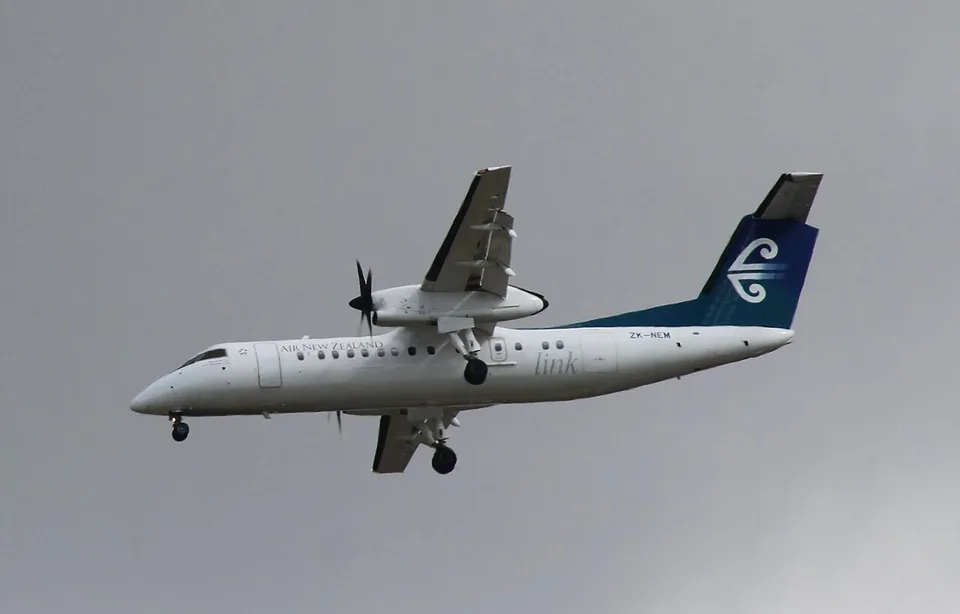
Wikimedia-generated 1280-pixel thumbnail, no editorial crop or content alteration. Responsive WebP copies resized without cropping.
Geographic context
Wellington departure
Timaru intended and actual arrival
Approximate schematic markers only. Lines between airports are not a recorded flight track. Basemap: Natural Earth, public domain.Read supporting evidence
NZ8199 approached Timaru in vertical-speed mode after an altimeter-setting procedure. The pilots became focused on finding airport lights and did not notice the continued 1,400 ft/min descent. The aircraft reached 1,156 ft above sea level before recovering and landing safely.
Read the full incident Follow what happened, from the flight to the investigation findings.
What investigators concluded
TAIC identified ineffective monitoring and crew coordination alongside systemic factors: a procedural workaround for an avionics-interface problem, training and oversight weaknesses, previous incidents inadequately addressed, and deficiencies in regulatory oversight.
What happened: looking for lights while the descent continued
1,530 words / about 7 minutes to read. Based on the investigation records cited below.
The last sector of the day
Air New Zealand flight NZ8199 left Wellington for Timaru at 18:05 on 13 June 2023. It was a scheduled passenger service in ZK-NEM, a Q300 carrying 33 passengers, two pilots and one flight attendant. The captain was flying and the first officer was monitoring. The captain had reached the last of four sectors that day; the first officer was on the last of five. Their shared flying earlier in the duty had taken them through New Plymouth, Auckland, Gisborne and Wellington.
Departure, climb and cruise were uneventful. Before leaving Flight Level 180, the pilots programmed the instrument arrival for Timaru's Runway 20 into the flight-management system. At 18:46 air traffic control cleared them to descend to 11,000 ft, which the first officer set on the altitude alerter. Later clearance allowed them to leave controlled airspace through the ELDAK and SUNPA waypoints.
That clearance removed further air-traffic-control altitude instructions, but did not remove the approach's terrain-clearance requirements. The programmed vertical-navigation profile was intended to keep the aircraft above those restrictions. The track was east of high terrain, so the relevant minimum altitudes were relatively low. TAIC nevertheless emphasised that adherence to them was a safety barrier, particularly during a night approach.
The captain set the altitude alerter to 400 ft once the approach clearance was received. The descent began at 18:56. TAIC later found that the derived decision altitude should have been 530 ft, and that the low selection did not provide adequate protection against the aircraft drifting below the earlier 2,000-ft restriction. An apparently small setting error was therefore one part of a larger loss of altitude awareness.
During descent through the transition level, the captain selected vertical-speed mode and the altimeters were changed from standard pressure to the local setting. On this Q300 configuration, using vertical-speed mode during that process was an established workaround. The flight-management system's avionics interface supplied only barometrically corrected altitude, rather than both corrected altitude and pressure altitude, limiting its ability to smooth the change during transition.
The practical consequence was a reliance on the pilots remembering to restore vertical navigation after the altimeter procedure. The captain did not do so. Flight data showed vertical-speed mode selected at about 14,946 ft and no subsequent restoration of VNAV before the deviation was recognised. TAIC found no explicit prompt that reliably closed that procedural loop.
The two modes do different jobs. A programmed VNAV descent follows a calculated vertical profile. Vertical-speed mode instead holds the selected descent rate. In this event that rate was 1,400 ft per minute. The flight director's centred command bars could therefore look reassuring while the aircraft moved progressively below the intended approach profile: the system was following the selected command, but the selected command was not the one the crew believed it was following.
The report treats this as more than an individual memory lapse. It identifies an unresolved design-compatibility issue that had existed since installation, and a workaround whose safe completion depended on prospective memory. The captain had encountered a missed mode restoration before, but had discovered it earlier. The danger arose when that vulnerable procedure met degraded monitoring, allowing the mode error to remain unnoticed long enough for the descent to become serious.
At 19:01, near 11,000 ft over ELDAK, the captain identified Timaru's city lights and pointed them out. The first officer soon reported seeing the precision approach path indicators and the aerodrome beacon. The captain could not positively identify those airport lights. The effort to reconcile what each pilot could see increasingly occupied both of them.
At about 7,000 ft the captain reduced thrust to slow toward 160 knots. The aircraft remained faster than expected. At about 3,500 ft the captain asked for increased propeller speed to create more drag, and asked the first officer to confirm that the runway lighting was on. Timaru had no local air-traffic-control service, so the first officer contacted the airline's ground staff, who confirmed full-intensity lighting.
The captain wondered about a tailwind, but TAIC explained that the continuing 1,400-ft-per-minute vertical-speed descent was itself helping keep the aircraft faster than an ordinary VNAV descent. The observation could have prompted a check of the mode and profile. Instead, it became another question being managed while attention remained fixed on the view outside.
There were several available cues: the vertical-speed annunciation, distance to the next waypoint and vertical-deviation symbols directing the pilots upward. The captain's map scale also made aircraft position relative to the next waypoint harder to see. Both pilots' instrument scans had deteriorated. They were conducting an instrument approach, so identifying runway lights at that stage was not an essential task. TAIC described the fixation as a reason that the flight-path monitoring barrier failed even though information revealing the error was available.
As the aircraft continued downward, it crossed BUDPA about fourteen nautical miles from the aerodrome and the captain selected the landing gear down. By then it was substantially below the programmed path. The captain became concerned that the aircraft seemed too low for its distance and asked for a reference-height check.
Before the first officer could answer, the captain checked the aircraft's lateral position and realised that the initial approach fix at SUNPA was still ahead. Checking the advisory display revealed the essential error: vertical-speed mode was still active at 1,400 ft per minute. The flight had not been following the VNAV profile.
Flight data recorded autopilot disconnection at 19:08:14, followed about two seconds later by increased engine torque. The aircraft continued briefly downward, reaching its lowest recorded altitude of 1,156 ft above mean sea level, or 1,022 ft above ground, before climbing gently. It was around 2,500 ft below the planned profile and approximately eleven nautical miles from the runway. The applicable initial-approach altitude was 2,000 ft.
TAIC states that the enhanced ground-proximity warning would have sounded if the captain had not acted. It did not sound before this recovery. That distinction is essential: the pilots interrupted the descent, and the warning system remained the last defence that would have followed had they not done so. The report establishes a serious loss of safety margin, but does not justify describing a mountain immediately ahead or calculating a precise number of seconds to impact.
During the climb the captain sighted the approach lights and elected to continue. The aircraft crossed SUNPA at 1,668 ft, still below the required initial altitude, then climbed to 2,000 ft and regained the correct profile. It landed at Timaru at 19:13 without injury or damage.
The captain initially felt that continuing the approach was the safest option once the profile was regained. TAIC's analysis was more cautious. Both pilots had suffered reduced situational awareness, and the captain's recovery actions were not fully verbalised. The first officer later recalled changing the altitude alerter to around 2,000 ft to silence its chime, but recorded data showed the selector remained at 400 ft until after touchdown. A go-around would have given the crew time to reassess the aircraft configuration and their understanding of the situation.
At 19:41 the captain submitted an internal safety report. Its initial description underestimated the deviation in distance and altitude. The voice recorder was not preserved by isolating its circuit breaker. After discussion with the airline's duty system, the crew were initially considered fit to operate the next day if rested, and did so.
When the safety team reviewed the event and obtained prioritised flight data, its seriousness became clearer. Both pilots were stood down on 15 June and an internal investigation began. The CAA was notified on 16 June and notified TAIC that morning. The progression from an initially limited description to a recorded-data reconstruction illustrates why a safe landing and an early crew report cannot by themselves establish the scale of a serious incident.
TAIC found that neither pilot was so fatigued that they should have been unable to operate, but concluded it was likely both had reduced alertness. The first officer had reported feeling tired during the final sector. The report retains that qualification rather than assigning every error to a proven fatigue cause.
The inquiry also identified shortcomings in crew-resource management, training and oversight, and differences in the Q300 fleet's safety culture. Six previous flight-path deviations had not been addressed adequately. TAIC connected those weaknesses to organisational integration and to ineffective regulatory oversight, including a relationship between regulator and airline that it considered too close. These are the Commission's findings, not assumptions added from the outcome.
In August 2026 TAIC recommended that Air New Zealand continue seeking an engineered solution to smooth VNAV descent through transition. The airline's September reply accepted the safety intent and described continued engagement with the manufacturers. It also said no technical solution was then available for its Q300 configuration. Calling that engagement implemented did not mean the underlying engineering change had been delivered.
A further recommendation asked the CAA to promote wider voice-recorder requirements through international channels. The event's central lesson remained the relationship between human memory and technical protection. The approach ended safely because the captain recognised and corrected the descent. The inquiry sought stronger defences so that the next flight would not depend on that late recognition after several earlier barriers had already failed.
A simplified reading of the investigation findings. The sequence does not replace the full report or imply that every contributing factor is shown.
Sequence of events
Report chronology uses New Zealand local time, NZST (UTC+12). Altitudes are above mean sea level unless stated otherwise. Lowest altitude was 1,156 ft AMSL, 1,022 ft above ground. Expand an event to see its evidence.
Did the ground-proximity warning rescue the flight?
No. The captain acted before it sounded. TAIC states that the system would have warned if descent continued and describes it as the final defence against controlled flight into terrain.
The aircraft was following the selected vertical-speed command. The error was failure to restore the intended VNAV mode, within a wider procedural and avionics-interface problem.
No. TAIC states that the aircraft was under instrument flight rules, so searching for runway lights was not necessary at that stage and diverted attention from monitoring.
TAIC did not find fatigue that prevented either pilot operating, but considered reduced alertness likely. That qualified finding differs from proving severe fatigue.
The report documents a serious safety-margin breach and a warning that would have followed continued descent. It does not establish a precise countdown to collision.
Actions and recommendations are described at the dates of the cited records. A recommendation is not proof of implementation.
Technical solution recommended
TAIC recommended continued engagement with De Havilland Canada to replace the transition workaround with a technical solution. Air New Zealand's September 2026 reply described continuing engagement and no available technical solution for its configuration.
TAIC recommended that CAA pursue broader CVR recording requirements through ICAO. CAA accepted further consideration while noting the required international process.
Matching dossiers for Terrain-clearance risk: No other dossier in this collection.
Read alongside
These comparisons connect specific research topics. Shared circumstances do not establish identical causes. Evidence from both investigations is provided below.
Both reports examine the gap between automatic guidance, crew monitoring and the aircraft's actual vertical path. NZ8199 stayed in an unintended vertical-speed mode and recovered before terrain contact. AC624 followed a displaced flight-path-angle approach and struck terrain before the runway. These are different guidance mechanisms and different outcomes.
Explore the records below for additional context. They open on the publisher's site and are not all included in our report search. Source reuse terms apply.
Authority publication record. Later revisions should be checked here.
Sources and transparency
Checked against the original final report. This account has not had independent expert review.
Source limitations
The ground-proximity warning did not sound before recovery. TAIC says it would have sounded had descent continued. The track was east of high terrain; this account does not invent an imminent mountainside collision or seconds-to-impact. CVR preservation limitations affected the inquiry.
TAIC final report: ZK-NEM
TAIC Official final report, released 1 October 2026
Transport Accident Investigation Commission final report. Privately retained for evidence checks; report imagery and third-party material are not reproduced. Source terms / provenance.
Aviation Investigation Report A15H0002: Collision with terrain, Air Canada, Airbus Industrie A320-211, C-FTJP, 29 March 2015
Transportation Safety Board of Canada Final report, released 18 May 2017; current E-1 edition, ISBN 978-0-660-09980-4
Non-commercial excerpts, attributed to the TSB and linked to the original version. No TSB endorsement. Third-party illustrations excluded. The TSB terms page was unavailable during the final link check.
Kevin Murphy writes the incident accounts on AirlineIncidents.com, out of a long interest in aviation safety and the lessons each investigation leaves behind.
Prepared by
AirlineIncidents editorial desk
Report citation check
Independent expert review
Not completed
Citation checks compare supporting text with the indexed report pages. They do not constitute independent expert review. How these pages are prepared.
Revision history
: Published sourced incident account, timeline, photographs and investigation findings.
.jpg)