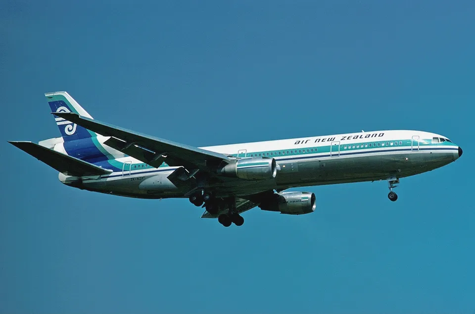
A changed navigation waypoint led ZK-NZP towards Mount Erebus. The Royal Commission found that whiteout conditions concealed the rising terrain from the crew.
Original PNG downloaded from Wikimedia Commons. Responsive WebP copies resized without cropping.
Geographic context
Mount Erebus crash site
Christchurch, intended next landing
The crash marker uses the coordinates radioed to Auckland after the wreckage was located. Christchurch marks the intended next landing; its city marker is approximate. Basemap: Natural Earth, public domain.Read supporting evidence
Flight TE 901 struck the northern slopes of Mount Erebus during an Antarctic sightseeing flight. All 257 occupants died. The Royal Commission found that the airline changed the destination coordinates without informing the crew, who expected their navigation track to follow McMurdo Sound.
Read the full incident Follow what happened, from the flight to the investigation findings.
What investigators concluded
The Commission identified the waypoint alteration and failure to notify the crew as the single effective cause. It found two contributing regulatory omissions involving plotted route maps and previous route experience, and found no contributing error by the pilots or flight engineers.
1,617 words / about 8 minutes to read. Based on the investigation records cited below.
A scenic flight with a changed route
Air New Zealand Flight TE 901 left Auckland on 28 November 1979 for a scenic passenger flight over Antarctica. Its next intended landing was Christchurch. The aircraft, ZK-NZP, carried 237 passengers and 20 crew. Captain Collins and First Officer Cassin were taking the DC10 towards the McMurdo area, where earlier sightseeing flights had descended to give passengers views of the scientific bases and the surrounding ice. The intended visit involved an overflight, with a return to New Zealand afterwards.
The navigation information given to the crew had changed between their Antarctic briefing and departure. At the briefing on 9 November, Collins and Cassin saw a flight plan whose McMurdo waypoint lay at 77 degrees 53 minutes south and 164 degrees 48 minutes east. The Commission concluded that Collins used those coordinates to plot the route on the evening before departure. That plotted track ran down the broad expanse of McMurdo Sound towards a waypoint near the Dailey Islands.
At about 1.40 a.m. on the day of departure, the destination coordinates in the airline ground computer were altered. The longitude became 166 degrees 58 minutes east, moving the waypoint 27 miles east. The resulting track led towards Ross Island and Mount Erebus. The crew received the altered flight plan and entered its coordinates into the aircraft navigation system. They were given no notification of the change. The Commission found that the small numerical alteration passed unnoticed among the many figures on the plan.
The navigation system followed its programmed track
ZK-NZP was a McDonnell-Douglas DC10-30. The Commission found that the aircraft had been properly maintained and was operating correctly throughout the flight. Its Area Inertial Navigation System used three independent sensor units to measure movement and compute position. With navigation mode engaged, steering signals could take the aircraft automatically between the coordinates entered by the crew. The display also supplied the distance remaining to the next waypoint.
Checks near the Balleny Islands and Cape Hallett showed the crew that the system was working with its customary accuracy. That performance strengthened their reliance on the programmed track. The Commission found that Collins expected the track to lead down McMurdo Sound. He had not received a topographical map showing the actual programmed route, either at the earlier briefing or at dispatch on the morning of departure.
The system allowed the pilots to leave the navigation track by selecting a heading. Successive heading selections could steer around cloud while the autopilot continued to control the aircraft. When navigation mode was armed again, the aircraft could intercept the programmed line and turn onto it. The flight recorder showed Collins using that sequence during the descent. Heading select directed the two orbits, and navigation mode then guided the aircraft back to the line leading towards Erebus.
McMurdo air traffic control also expected the aircraft to approach along the Sound. Its staff understood the destination waypoint to be west of McMurdo Station. The crew and controllers therefore approached the descent with a shared geographical expectation. The track actually programmed into ZK-NZP took it into Lewis Bay on the northern side of Ross Island. The difference placed the aircraft in front of the rising slopes of Erebus.
At 12.17:13 p.m., McMurdo time, Collins proposed beginning the descent. Mac Centre reported a low overcast around 2000 feet, some snow and visibility of about 40 miles. It offered radar vectors down to 1500 feet once the aircraft was within 40 miles. The crew accepted the offer. Collins told the passengers that the aircraft would initially descend to 18,000 feet and that a radar letdown was expected to provide a view below the cloud over McMurdo. He also warned that changing weather could require a different course.
The crew made repeated attempts to contact the Ice Tower on VHF, while maintaining communication with Mac Centre on HF. With roughly 60 miles remaining, the cloud below had broken into widely separated patches. Large areas of sea and ice were visible. The aircraft then made two descending orbits through clear areas. The Commission described the shape of the turns as governed by the need to maintain visual meteorological conditions, which the airline directions required to include 20 kilometres of clear vision.
After the second orbit, Collins reselected navigation mode and the aircraft recaptured its programmed track. In the final radio exchange, ending at 12.45:08 p.m., the crew reported descending from 6000 feet towards 2000 feet in visual conditions. Mac Centre acknowledged the message and waited for the aircraft to arrive. The aircraft continued below the overcast, then descended to 1500 feet. Its path was carrying it towards the mountain.
The air below the cloud was clear. Passenger photographs recovered after the crash showed distant shorelines on both sides of the aircraft shortly before impact. The Commission identified Cape Tennyson to the left and Cape Bird to the right. It concluded that these features had been interpreted as the sides of McMurdo Sound. In Lewis Bay, the snow surface ahead rose towards Erebus beneath a solid cloud layer. The visible black shoreline at Cape Tennyson was about 13 miles away, and Cape Bird was about 10 miles away. Those views established clear air across at least 23 miles beside the aircraft. Ahead, the white surface continued towards the mountain with very little contrasting detail. The Commission described two small strips of rock near the ice cliff that might have been hidden by the aircraft attitude or mistaken for strips of sea between pack ice.
The Commission found that the lighting created a whiteout visual illusion. Uniform snow, a continuous overcast and the absence of contrasting forward landmarks removed the visible definition of slopes and ridges. The rising surface appeared to continue as a flat white expanse. The aircraft was flying beneath the cloud, and the hidden slope merged visually with the cloud above. No one on the flight deck identified the approaching mountain.
Collins sought contact with the TACAN distance equipment and then asked for further attempts to raise the Ice Tower. The Commission inferred that he wanted an independent check of distance because expected landmarks had failed to appear. He said that they were 26 miles north and would have to climb out. The pilots were still discussing which direction to take when the ground proximity warning sounded. Collins attempted to fly away from the terrain. The aircraft struck the northern slopes of Mount Erebus at 12.50 p.m., approximately 1500 feet above sea level. Everyone aboard died.
Recorders and passenger cameras recovered the sequence
The United States Navy searched after the radio silence and located the wreckage. The crash coordinates sent to Auckland were 77 degrees 25 minutes 30 seconds south and 167 degrees 27 minutes 30 seconds east. The flight data recorder and cockpit voice recorder were recovered undamaged and sent for examination. The recorded flight path showed the two orbits, the return to navigation track and the subsequent approach towards Erebus. Examination of the flight data also established a straight and level course at 260 knots as the aircraft reached the mountain.
Many damaged passenger cameras still contained intact exposed film. Development of those films produced hundreds of photographs, including images taken within seconds of the collision. They supplied evidence of the weather and the views beside the aircraft. Some film recorded the final moments, but the recovered photographs supplied no view directly forward along the direction of travel.
The voice recording captured the last 30 minutes of flight. The Commission found that speech by the two pilots was clear, while cross talk from people behind them was much harder to interpret. The pre-descent briefing occurred before that recording interval and its precise contents remained unknown. The Commission reconstructed the likely plan from the subsequent exchanges and the recorded flight path. Its assessment of the crew intentions therefore included inferences from that surviving evidence.
The Commission identified an administrative failure
Justice Peter Mahon submitted the Royal Commission report on 16 April 1981. The Commission identified the alteration of the destination coordinates, combined with the failure to inform the crew, as the single effective cause of the crash. It traced that act and omission to the airline Flight Operations Division. In its conclusion, neither the pilots nor the flight engineers made an error that contributed to the disaster.
The Commission examined how the Navigation, Computer and Flight Despatch sections exchanged operational instructions. It found defects in both administrative structure and communication. There were no written directives specifying how adjustments to flight plans and navigation procedures were to be transmitted. The instruction to change the destination coordinates was verbal. There was no written confirmation from the Computer Section that the change had been made, and no written direction to dispatch to tell Collins.
Executive pilots also flew operational duties and could be away for days. The Commission found no official recording system that would tell them what had happened in their departments during those absences. Duties and administrative responsibilities lacked written definition. Within dispatch, there was no requirement to keep an exact list and current copies of the documents supplied in the Antarctic Envelope. The Commission could not establish the precise contents of that envelope on the fatal flight.
Altitude approval was another disputed issue. The officially specified limits included 16,000 feet on the approach to Ross Island and a limited descent to 6000 feet elsewhere. The Commission found that actual sightseeing practice had long involved much lower flight in visual conditions, with airline briefings authorising levels approved by McMurdo controllers. It concluded that the Civil Aviation Division had known of that practice. It also identified two regulatory contributions: failure to ensure crews received a topographical map with the programmed track plotted, and removal of the requirement for a previous flight over the route. The Commission recommended changes to public inquiry procedures and clearer legal definition of accident investigation powers.
A simplified reading of the investigation findings. The sequence does not replace the full report or imply that every contributing factor is shown.
Sequence of events
Flight sequence times use McMurdo local time as stated by the Royal Commission. The pre-departure computer change uses the time stated for Auckland. Expand an event to see its evidence.
9 November 1979Antarctic briefing
Collins and Cassin receive flight plan coordinates showing a route down McMurdo Sound.
The destination waypoint was moved 27 miles east before departure. The Commission found that the crew received no notification, and entered the altered coordinates while expecting the route shown at their earlier briefing.
The crew made two descending orbits through clear areas, then recaptured the programmed navigation track and continued below the overcast. The Commission found that the turns were shaped to maintain visual meteorological conditions.
The Commission found that uniform snow beneath a solid overcast created a whiteout visual illusion. The rising ground appeared flat, and the people on the flight deck never identified the mountain before impact.
The briefing fell outside the last 30 minutes captured by the voice recorder. The Commission reconstructed the likely plan from later exchanges and flight data.
The Commission inferred that the aircraft probably appeared briefly on the Ice Tower radar. Neither the radar operator nor the radio operator was available to give evidence.
Actions and recommendations are described at the dates of the cited records. A recommendation is not proof of implementation.
Operational administration
The Commission identified absent written procedures for communicating flight plan changes and an unrecorded instruction to alter the destination waypoint.
The Commission identified the absence of required plotted topographical maps and the removal of the previous route flight requirement as contributing regulatory omissions.
The Commission recommended amending Regulation 17 to clarify when a public inquiry could be directed and to define the chief inspector role as a fact gathering agent for that inquiry.
The Commission recommended that accident investigation procedures be specified in regulations to give public notice of investigators rights and responsibilities.
Matching dossiers for Route mapping and familiarisation: No other dossier in this collection.
Read alongside
These comparisons connect specific research topics. Shared circumstances do not establish identical causes. Evidence from both investigations is provided below.
Both investigations examined navigation towards mountainous terrain. The Erebus Commission traced the fatal track to an unannounced ground computer waypoint change. Aerocivil identified inadequate approach planning and execution, inadequate use of automation and loss of situational awareness in American Airlines 965.
Explore the records below for additional context. They open on the publisher's site and are not all included in our report search. Source reuse terms apply.
Mahon Commission findings, navigation evidence, weather analysis, administrative findings and answers to the terms of reference.
Sources and transparency
The Royal Commission submitted its completed report on 16 April 1981.
Source limitations
The pre-descent briefing occurred before the cockpit recorder interval. The Commission inferred its likely contents from the subsequent flight and conversations.
Report of the Royal Commission to Inquire into the Crash on Mount Erebus, Antarctica, of a DC10 Aircraft Operated by Air New Zealand Limited, 1981
Royal Commission of Inquiry, New Zealand Final Royal Commission report, submitted 16 April 1981
Kevin Murphy writes the incident accounts on AirlineIncidents.com, out of a long interest in aviation safety and the lessons each investigation leaves behind.
Prepared by
AirlineIncidents editorial desk
Report citation check
Independent expert review
Not completed
Citation checks compare supporting text with the indexed report pages. They do not constitute independent expert review. How these pages are prepared.
Revision history
: Published sourced incident account, timeline, photographs and investigation findings.
Quoting this account or linking to it? Please use the page address below, and credit the investigation report it is built from.
Credit line
AirlineIncidents.com. Air New Zealand 901 accident account. Published 16 October 2026. https://airlineincidents.com/incidents/air-new-zealand-901-1979/
HTML link
<a href="https://airlineincidents.com/incidents/air-new-zealand-901-1979/">Air New Zealand 901 accident account (AirlineIncidents.com)</a>
Select a box to copy it. Spotted something wrong? Send a correction.